TIME
TRAIL TYPE
Equestrian
DIFFICULTY
Medium
DISTANCE
13263 metres
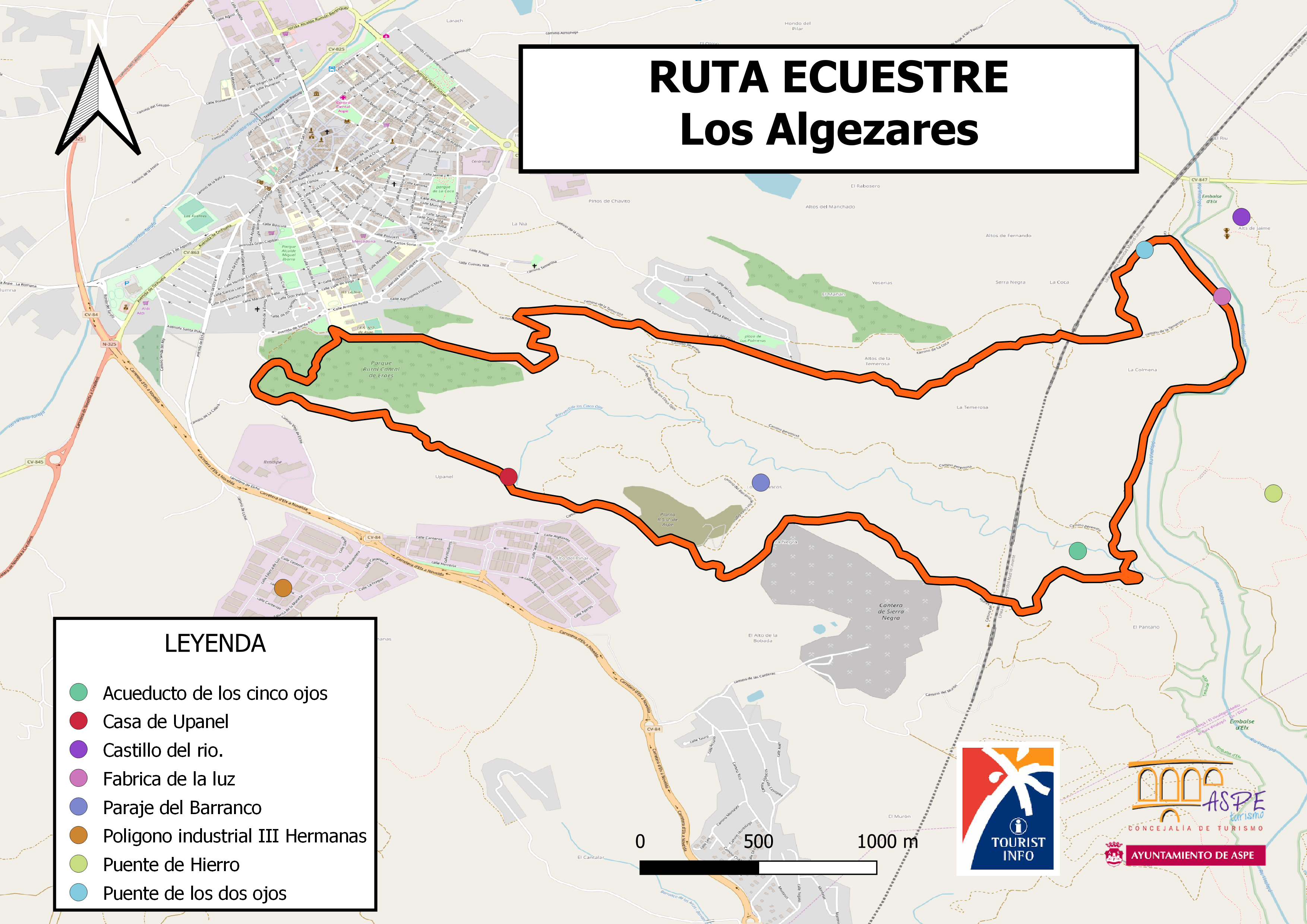
Our starting point for this trail is at Cantal de Eraes, opposite Villa de Aspe’s secondary school. Our itinerary goes around the hills comprising this natural site that have been subject to several reforestation projects. These include the Aleppo pine (Pinus halepensis) reforestations undertaken some decades ago and, more recently, the activities involving native shrub species carried out by school children.
We head along Upanel track to reach the natural site of the same name. This is a natural site of vast scenic interest, featuring reddish soils due to the prevalence of clay, as well as marl and gypsum. With the action of torrential rainfall, these easily eroded materials have created gullies and a complex network of ravines. Visitors can also observe the old clay quarries previously used by the traditional roof tile factories to manufacture building materials. We continue along the same Upanel track to reach the ruins of Casa de Upanel, a farming operation that remained active until the mid 20th century.
Upanel track then leads us to a tarmac road that connects Tres Hermanas Industrial Estate with a decommissioned landfill site. Our route continues along the landfill’s right hand side to reach Casa de la Monfortera track. From here, we reach Barrancos natural site, where once again the water played a leading role in modelling the clayey materials. Our itinerary heads to the right of Sierra Negra mountains, where we can observe a limestone quarry before passing Casa de la Monfortera, another farming house in ruins dating from the early 20th century.
We then continue underneath the AVE fast train railways where, after an ascent, we arrive at Puente de los Cuatro Ojos bridge. We continue descending towards the mouth of Barranco de los Cinco Ojos ravine. Please remember at this point to avoid walking on flood plains and ravines during the rainy season. Following, we take Peremina track to join Puente de Hierro track towards the north along Vinalopo river course, where we can see the riverbed infrastructures that are part of a diversion to send irrigation water towards Elche. Puente de Hierro, a bridge that disappeared after a heavy flood, is perhaps the most emblematic element in this area. Our itinerary then heads towards a car park where we find the old Molino de Caraseta facilities that were transformed into Fabrica de la Luz hydroelectric station (1895).
We continue our trail amid conglomerate, a typical material in a riverside area such as this one, to reach the ruins of Molino del Coquero, one of the old local flour mills, before changing direction. Another remarkable sight are the ruins of 13th century Castillo del Rio castle on the opposite side of Vinalopo river. We return to the urban centre is via an ascent along La Temerosa track, from where we can admire Fuente de la Coca fountain, before continuing along the track of the same name to reach Santa Elena development.
Before accessing the urban area, our route takes a left turn to return to La Temerosa track. From this point, we head westwards towards the Y junction with Peremina track. Another change in direction leads us via a descent along the latter for about 150m, before turning right and advancing towards a dip. In this manner, we continue along a dirt track before taking Rincon de Morera and Vistahermosa tracks, in order to return to Cantal de Eraes.


